The story so far
June 24, 2010
N.B written on Tuesday…
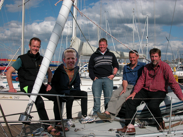
We are rolling around in a very light breeze, inching towards the Mull of Kintyre, with no other yachts in sight. We may be in about 5th place but we’ve not checked the tracking web site for a while, and our tracker is on the blink anyway, only sending our position occasionally. The calm conditions mean a) I can write this, and b) Stewart is feeling fine, with not a bucket in sight. Here’s Stewart and Ben yesterday evening after the wind had dropped.

Back to Saturday… the jostling for the start was quite tense, though apparently quite relaxed and polite compared to an out-and-out sailing race, wheeling around checking watches and trying to hit the start line as the horn sounded (too soon means 1 hour penalty).

We got a flyer, crossing the start line in about 2nd place, and feeling the elation of the race being under way at last. Great to be flying along with the really fast boats.

And then we flew straight into a hole in the wind, that seemed to be about the size and shape of Autonomy… boats ahead and to the left of us were heeled over doing 6 knots, we were standing still feeling despondent for 20 minutes. Damon texted and asked if we had remembered to lift the anchor.
But soon we found wind again, and began a really lumpy ride out to Bardsey Sound, very rapidly establishing that Stewart had left his sea legs at home. I saw the sailors exchanging some “here we go again” looks, remembering the Scottish Islands Peaks Race 2008… But once he’d made friends with the “bucket of shame”, Stewart kept it together and worked out how to cope – in bed. I felt really bad as well, and almost chucked a few times.
Great sailing pulled us back through the fleet, and we reached Bardsey in perhaps 10th place.

Sometime in the night, we started getting messages from support crew Mike and Sally and others wondering if we were wrecked and clinging to a rock… our tracker had stuck, and it was only hours later we managed to get messages back to them that actually we were coming in to Carnarfon nicely.

We had no delays crossing the Carnarfon Bar, and so Stewart and I jumped off for our first run at 03:50 on Sunday – a lovely time for a run, especially a 24 mile one up Snowdon. The first challenge was finding our way through the lanes of Carnarfon, and negotiating safe passage with the pissed up locals who had fun chasing us and offering us White Lightning etc etc. On the 8 mile road out to the Ranger path we quickly overhauled Krishna’s runners (Israeli) who were perhaps used to running in the Negev, because they were wearing several layers head to toe, and running very slowly. Madam Wen’s runners (“Marvin” and Tobi Staines) were just behind us until we started the climb, when they dropped back fast. Were we over-stretching ourselves…? We felt good so just got on with it.
After grabbing food and bottles from Mike and Sally we hit the hill, climbing into cloud, until we detected that there was sunshine above. The summit stretch was stunning, with views of clouds and crags all around.

The summit was reached in about 2 hours 20. We were told we were now 9th, and the only team to run the summit stretch!

I immediately turned my ankle while faffing with the camera, and Stewart hurtled off into the distance. Luckily I found my ankle again quickly, and caught up about half way down, passing two other teams (Sea Fever? and Moby J, whose runners looked absolutely shot).
The road back was a struggle, and my un-recce’d “shortcut” in Carnarfon turned out to have a 40 degree hill, but we made it to the boat, where Naomi and kids were watching. The kids seemed visibly dismayed – “Daddy you hardly look tired at all”! I was hiding it well.

Must just get some food – feeling a bit faint…
Mmm much better; rice pudding and a tin of fruit. Anyway, after Carnarfon comes the Menai Straits and the infamous Swellies. Light wind eased us to the first bridge where the fun starts, with Moby J and Sea Fever for company.


Then as we picked our line through the right-hand span, we saw that White Cloud was lying on her side on rocks just beyond the bridge. That was her race over.

Then a few minutes later, Sea Fever also grounded gently, showing us where not to go; she got off at the next tide and is now ahead of us again. A very nervy couple of hours saw us out into open sea past Puffin Island.

The sail to Whitehaven was much smoother, to Stewart’s relief, and we got some rest in preparation for the big Scafell Pike leg.

At Whitehaven harbour, we caught the leaders waiting to get into the harbour through the sea lock – a bit of lucky timing in our favour. They let EADS Innovation Works in first because she was the shallowest, giving us a 20 minute wait or so. Then we went into the lock with Kishinoor, Moby J and Torbellino.

Mike and Sally had our bikes at the kit check, and we set off a few minutes behind the Moby J runners, at 04:15, to cycle the 16 miles to Gillerthwaite YHA in Ennerdale. The pressure was on – the sailors had worked out that we needed to be back before about 11:45 to get out of the sea lock before low tide, giving us 7.5 hours to complete the leg. From past results I knew most teams take well over 8 hours, and although I knew Stewart and I were capable of the required time, I was not confident we could achieve it now. I took it gently on the bike, though Stewart had to try a bit harder as he was on a mountain bike frame wile I was on a roady. We eased off stiff legs, and arrived just behind the Moby J pair. After the 5 minute time-out, where Stewart made comprehensive use of the facilities, we started the run to Black Sail pass. After a quick chat, we left the Moby J’s behind and got into a great rhythm. Mike and Sally were at Wasdale Head as planned, with pots of custard and fruit – much appreciated. We knew EADS were 30 mins ahead at the start, so it was nice to hear the gap had not increased.
The Scafell climb is a real slog, made harder by literally hundreds of Three Peaks walkers coming down the same path.

We gained the summit in 1:10 from Wasdale, which was inside my targets, but the crux of this leg would be whether we could keep speed climbing back over Black Sail pass.

We flew down nicely, passing lots of following teams – oddly none of them had seen the leaders EADS’s Martin Beale and Indge – they must have taken a different descent route away from the main path, because Mike and Sally confirmed they returned 30 mins ahead still.
We slogged back over Black Sail and down the long forest track to the YHA, conquered the brutal hills out of Ennerdale on the bikes, and then started really motoring on the cycle track.

I led on the faster bike, Stewart draughting on my back wheel. After 40 minutes of this, and negotiating the twists and turns back into Whitehaven, I was genuinely as knackered as I’ve ever been, and just fell onto the boat after giving my Mum a very sweaty hug. We were back in time, at 11:30, after completing the leg in 7 hours 15 or so.
Our jubilation was short-lived… just outside the sea lock we ran aground somehow, and frantic bouncing on the boom, thrashing the engine, pulling with the anchor winch, etc wouldn’t shift us an inch. As the tide departed, the sailors hung their heads in shame…

… until they realised they could blame us – if we had run a bit faster the water wouldn’t have been so shallow!
Anyway, when the tide lifted us off we were still in 2nd, though we now had a chasing fleet of faster boats who overhauled us in the light evening winds. We are now lying 7th.
We’ve just checked the race web site, which has us in the lead after Whitehaven somehow, showing that we were 2nd on the Scafell Pike leg, only 1 minute behind the EADS pair in 7:10. Very chuffed, and if Stewart hadn’t needed to wash his hair four times in streams we might have nicked it!
Looking forward to the Ben.
Tumbelina
May 25, 2010
I went arse over breakfast on a steep grassy descent yesterday evening. I’d fitted in a quick blast up the local monster-hill on my bike at lunchtime, and was out for a 45-minute run while the boys were at karate when I lost control and fell headlong, bouncing off a couple of rocks. One grazed and bruised my ribs quite badly (although, despite what Anna maintains, I don’t think any are broken) and another caught my left quad just above the knee. Today the leg is puffy but pretty OK, the ribs are easing a bit (no pain-killers needed) but I seem to have whiplash, and can’t turn my neck nearly as much as usual.
Made use of the enforced rest by stripping the bike down, giving it a good clean, replacing a worn chain and fitting more sturdy tyres to withstand the forest track in Cumbria. It’s now running so smooth that I can free-wheel uphill! Hurrah – and as a bonus, I have quite macho-looking oily hands and chipped finger-nails.
Nice Bianchi
May 21, 2010

And on board it’s Damon at the end of the Etape Caledonia. We’ll be doing a lot of grimacing in the 3PYR, so this was quality training. Damon promises to write this up, but just in case, he finished the extremely hilly 81 miler in 4 hours 10, which is pretty darned good.
Trundling along
May 10, 2010
Crispin’s reports of his efforts over the last couple of weeks leave me quaking. I have managed a few 1-hour runs and a couple of bike rides. Yesterday’s 50-miler on the bike was a bit of a tonic for my achilles, which have been feeling a bit creaky lately, and this morning they are pain-free. I’ve a terrible lassitude about me, however. I think it may be a result of my Dad’s death three weeks ago, which has affected me in unexpected ways. We had a huge family get-together in his memory last weekend, and fed 50 in my house on Saturday evening and 30 for Sunday lunch. Fabulous weekend, but the preparations for the inundation of guests, coupled with the organising of his memorial service and the writing and delivery of a eulogy have left me pretty wrung-out. In these circumstances, my brief forays into the hills have taken on a fresh perspective, and have been very good for clearing the head. I’m plugging away and hoping that the weariness will soon lift and the bounce will return. I have an 80-mile bike ride (race?!) next weekend, and am determined to get out for a couple of really long runs before the end of the month. Injury-free and managing to avoid lurgies with the daily consumption of several kilogrammes of Vitamin C, so at least I have a fighting chance of turning up for the 3PYR in half-way reasonable nick.
Scafell Pike recce (wreckage?)
April 10, 2010
We’ve been up at my Mum’s house near Cockermouth, so I took the chance to recce the Scafell Pike route.
The running route
My first outing was the run, and instead of starting from Gillerthwaite YHA I parked at gatesgarth in Buttermere and started over Scarth Gap, joining the race route at Black Sail hut. This added some ascent to the route, but perhaps left off some distance. The hills were saturated with melt-water and recent rain.
From Ennerdale the route goes over Black Sail pass, which I had not done in this direction before. The path is obvious in daylight, but I reckon it could be a bit tricky in the dark, both up and down.
Here I am emerging over the top of Black Sail pass, looking over towards Red Pike and Mosedale.

The path on the Mosedale side is lovely – impossible to miss in the dark all the way down to the Wasdale Inn.
The next picture is taken from about half way down, looking into Wasdale. The peak on the right is Stirrup Crag, a subsidiary top of Yewbarrow.

Being in Wasdale Head reminded me of a fantastic day some years BC (before children) when stockbroker Jon mashed his knee on the Corridor Route, I tried to run up Great Gable from Styhead (long before I started running!), I took pics of Baa and Gavin climbing Nape’s Needle, while Naomi nursed Jon in the pub.

Here’s Wasdale, from the start of the climb, where the real task soon becomes apparent… Wasdale Head is just above sea level, while the top of Scafell Pike is only about 2 miles away at 977m.
 The 3PYR route is, as I understand it, Lingmell Gill to Hollowstones, then left to approach the summit from the Lingmell side. This photo shows the Hollowstones area, where things could certainly be a little confusing in the dark, and the path is marked by occasional small cairns among the boulders. I then followed the tourist path to the left of all the craggy bits, though I wonder if there’s a quicker route up one of the snow-filled gullies.
The summit area was quite snowy, though I doubt we’ll need to worry about that in June.

I was a little weary at the summit, because I’ve not done much going up massive hills since coming back from injury last July, but the fantastic weather and views were keeping me breezy.

It was on the way down I started to realize how hard this leg will be – it’s really steep and rocky, and where the going is not just fractured rock then it is man-made boulder paths; I could feel my thighs turning to mush with every step.

Here we are nearly down, looking back towards Wasdale Head and Mosedale, with Black Sail pass heading away up to the right behind Kirk Fell.

Needless to say, I hauled, crawled and clawed my way up Black Sail pass and then Scarth Gap, a shambling wreck by the time I reached the car nearly 5 hours after departure, though perked up marvellously by a large ice cream with flake and raspberry sauce. Here’s a map showing the bits from Black Sail hut down to Scafell Pike. Next… the bike route!

The cycle route
The next day I drove down to Whitehaven to recce the bike route. I found a car park where one machine said “Out of order – please use other machine” and the other machine said “Out of order – please use other machine”, and the verdict among us honest but bewildered punters was that it was free parking day. I went to the harbour office, and a nice lady showed me exactly where the boats come through the harbour wall in the race (the harbour is completely sealed, with a sort of revolving door thing that opens for boats) and where they drop the runners before berthing. All very straightforward compared to the bonkers dinghy frenzy in the SIPR! She said supporters will be able to park on the marina pier.
The cycle route is not exactly hard to find, but I’m really glad to have recce’d it anyway, because there is a one-way system and it wasn’t quite in the direction I was expecting. In fact the route is well signed as the C2C cycle route with clear blue signs and bollards. The first couple of miles go through, umm, how do I put this politely, umm, well it’s a bit like Soweto or a run-down suburb of Belgrade. Wear chewy tyres, coz the route is covered with broken glass and rubbish, and skanky blokes exercising their pit-bulls. Despite a few turns and junctions, this route should be easy to follow, and soon it’s out in the open country, following the old railway line gently uphill all the way to Rowrah and Kirkland. Then onto the road and down into Ennerdale and onto the forestry track to the Youth Hostel.This is where I was wondering whether the road bike would be such a goood choice, but in fact it was fine, because I had put larger tyres on and the track is fairly benign. There were only a couple of short sections where I really wished for knobbly tyres and suspension, though I might change my mind when doing the ride after several hours of running!
It has to be said that the return route does feature some fairly savage hills, and one complete monster, but I’m going to blank that out for now.
Med Veg
February 2, 2010
I am battered and bruised. Circuit training again this evening, with a new bastard calling the shots. And a brisk run at lunchtime.
But what about the veg… while working with the Oxfordshire archaeologists last Friday, I popped round to Café Loco for a bite to eat at lunchtime. The board showed various baguette fillings, including “Houmous and med. veg.”. When I reached the front of the queue, I was horrified to hear myself order “a baguette with houmous and medieval vegetables”. The lady gave me a very funny look. In due course I was relieved to find the vegetables in my baguette were quite modern.
While in Oxford I managed a 30 minutes blast along the Thames towpath in gathering gloom, and one of those crack of dawn runs that gets the bowels really moving when you are farthest from home. On saturday, 2 hours up the snowy lanes and tracks to the Storey Arms, from home and back.
Then on sunday my finest hour… I pretty much couldn’t face running any more, so set off on the bike over the Eppynt, and then it started properly blizzarding. I couldn’t see, I couldn’t ride, I couldn’t feel my feet or fingers, snow was actually lying – on me. I made it to the Co-Op in Builth, where I phoned home for a rescue (my second in a month!). Pathetic. Had to eat 6 Mr Kipling slices while waiting, and some sandwiches.
Long Mynd Race this weekend – known to pack in more pain and suffering per mile that any other fell race.
The running/cycling routes
January 3, 2010
We’ve not been sent the official route maps yet, but here’s what I’ve gleaned from various sources, mainly Martin Beale on the FRA Forums:
Caernarfon / Snowdon
The route up Snowdon is from the wharf in Caernarfon up the A4085 road that goes to the south of Snowdon, up the Snowdon Ranger path to the summit (where there is the only checkpoint), down the railway path to Llanberis and then back along the A4086 road to Caernarfon. There isn’t much route choice.
Whitehaven / Scafell Pike
From Whitehaven follow the C2C cycle path / West Cumbria Cycle Path to just west of Kirkland NY 062 178. Turn left at the road, after about 300m turn R at crossroads by Kirkland school, up the hill after 800m to crossroads in Kirkland. Straight across then follow the road to a T-junction at Cauda Brow (FRA relays 2009 venue!), turn right and drop down to Croasdale (turn left into village), then continue to end of road and onto 4km of stony forestry track to the Gillerthwaite youth hostel at the head of Ennerdale Water. Run up the valley and then over Black Sail Pass to Wasdale Head (checkpoint), then up a diagonal path (via the charmingly named “Brown Tongue”) to the main path to Hollow Stones. Then go left a bit to the col between Lingmell and Scafell Pike, then straight up to Scafell Pike (this last bit is how you would finally ascend Scafell Pike if you’d done the Corridor Route from Styhead).
Corpach / Ben Nevis
Dock at Corpach lock, run along the “coast path” by Caol (Great Glen Way) in a SE direction. Cross river on a footbridge by the Mallaig railway line bridge (I think it is the same bridge, but may be wrong there). Run through Inverlochy, then up the north / east bank of the Nevis river along the minor road. Pass Achintee House, then up the main Ben Nevis path. You’re not meant to take the Red Burn path shortcut (I think that’s what it’s called), but can cut the zig zags after that (according to choice). The checkpoint is on top of that big cylindrical cairn on top. The way back is the same as the way up. The finish line is by the lock in Corpach. There is only one checkpoint on this leg: at the top.
Don’t forget the bikes
January 2, 2010
Lest anyone get the impression this race is all about running and sailing, don’t forget the 30 miles or so on the bikes (Whitehaven to Ennerdale and back). Like Autonomy, my bike (Kinesis Tk Racelight, a “winter trainer”, aka “shopper without a basket”) is in dry dock at the moment having the barnacles scraped, and generally performing the duties of clothes horse in the front hall. Here she is sporting fell running garbage. Actually I went for a spin a week ago (with no kit), got a puncture and had to be rescued, doh.